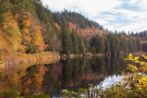
By Hannah BlankA short drive south of Bellingham off exit 242 to Nulle Road, lands you at the trailhead for Squires Lake. The trail is currently covered in vibrant fall colors, leaves litter the ground and little mushrooms poke out of the moss.
Squires Lake trailhead. // Photo by Hannah Blank
A steady, uphill 0.4-mile jaunt will bring you to this picturesque, tree-lined lake with numerous trails available, including one trail around the entirety of the lake. The Washington Trails Association advertises the Squires Lake Loop as a moderate hike, good for anyone of all ages.For those looking to get their steps in, the Alger Alp path that breaks off from Squires Lake is a great trek that gives you a view of the valley. After reaching the lake, take a right to the Pacific Northwest Trail and stay on it until you reach the South Ridge Trail, forking off to the right. This is a consistent uphill climb that eventually turns into the old logging road, Forest Road 1340.
Scenery during the hike. // Photo by Hannah Blank
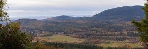
Something to note is the severe lack of trail markers leading the way to the eventual lookout point. The majority of the trail is obvious, but there are numerous forks that lead off into the woods without signage. There are white painted markers on trees that act as breadcrumbs to the correct path, but are sporadic at best. Eventually, you reach an intersection of Forest Service Road 1000 which will then take you to the west-facing viewpoint on part of the Chuckanut Mountains.
Views from the top of the trail. // Photo by Hannah Blank
Despite the confusing directions, Squires and Alps are great hikes that can be as short or as long as one would like to make them. The diversity makes it great for a day of exploring nature and getting to see what the Chuckanuts have to offer.


