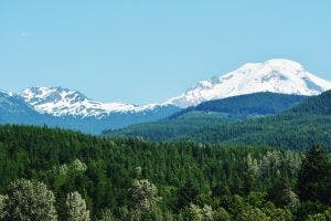
Towering above the city of Bellingham, Mount Baker is an active volcano capped with glaciers. The mountain is a popular outdoor recreation destination year-round. The Mount Baker Highway could be a good choice if you are a motorcyclist looking for a scenic summer drive.
Rolling foothills covered in evergreen trees lead up to the glacier capped volcano.
The highway starts in Bellingham and is formally known as WA-542. According to the Washington State Department of Transportation, the highway was just recently cleared of snow up to Artist Point on June 29 and is now open to all motorists. To reach the start of the highway, Google Maps suggests taking exit 255 from I-5 to WA-542. Follow the highway eastward through rolling foothills and rich farmland. The highway passes through multiple vineyards including the Mount Baker Vineyard and Winery. According to the Mount Baker Vineyards website, tours and wine tastings are offered daily. If you continue down the highway you will cross over the teal-colored Nooksack River. According to Google Maps the highway follows the Nooksack almost to its source, Mount Shuksan. Your last chance to fill up your motorcycle with gas will be in Maple Falls. If you are looking to stretch your legs, Silver Lake could be a nice pitstop. Heading north on Silver Lake road out of Maple Falls you will reach Silver Lake Recreation Area. The lake offers picnic tables, rowboat rentals, trails through deep green forests and lots of open space beside a large mountain lake.
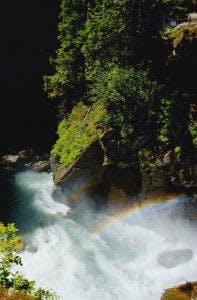
A rainbow forms at the bottom of Nooksack Falls as bystanders observe from the top of a cliff.
One final stop you might want to make on this scenic highway is Nooksack Falls. According to the Northwest Waterfall Survey, the waterfall drops 88 feet in two segments. The roar of the falls echoes throughout steep canyon walls while soaking the surrounding greenery with a cloud of mist. Further up WA-542, the highway begins gaining elevation. According to the Washington State Department of Transportation, the highway climbs to an elevation of 4,250 feet. This gain in elevation gives motorcyclists 360 degree views of the dramatic peaks and valleys that surround Mount Baker. There is lots to be explored along this section of highway. Winding through the mountains on a motorcycle allows you to soak up all the sights, smells and sounds of the Pacific Northwest. Driving from Bellingham to the end of WA-542 takes about two hours or it could take multiple days; it all depends on how many stops you decide to make along the way. All photos courtesy of Mathew Roland.
